 |

The central valley of Oaxaca is a mountain highland encompassing
3,375 square kilometers (1,303 square miles), at an elevation
of approximately 1,550 meters (5,115 feet).
A central
ridge system defines the valley as three separate,
smaller valleys: the Tlacolula Valley, extending 50
km east; the Etla Valley, reaching 40 km north; and the
Zimatlan Valley, which stretches a full 100 km south
to Miahuatlan, where the land rises before dropping
to the lowlands of the Isthmus of Tehuantepec.
The desirable agrigultural
land of the valley bottoms covers approximately 1100
square kilometers (700 square
miles), and it is not surprising that this is where
the earliest settlements are found.
The Geography of the Oaxaca Valley may be explored using any of the
maps or articles on this page. The archaeological sites
of Monte
Alban, Mitla and Dainzu may
also be explored through articles, color photographs,
and site plans.
View Larger
|
|
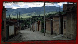
Teotitlan del Valle
The weaving tradition in Teotitlan
del Valle goes back to pre-Hispanic times. Teotitlan
even had to pay tribute to the Aztecs in the form of
cloth. Today, in the mercado de artesanias in the center
of the village, the full variety of tapetes and sarapes
are on display. Not all of the designs are traditional;
woven versions of Miro, Picasso, and even Escher are
available.
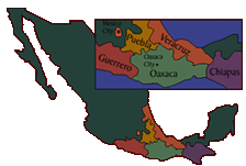
The map of Mexico shows the area in which the
Zapotec rugs are woven; the village of Teotitlan del
Valle is located in the Oaxaca Valley.
Oaxaca Valley
 View
a map of the Oaxaca Valley showing the areas of early
Zapotec occupation, as well as the weaving village
of Teotitlan. View
a map of the Oaxaca Valley showing the areas of early
Zapotec occupation, as well as the weaving village
of Teotitlan.
|
|